古墳時代の溝
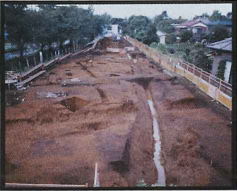
(狭山遺跡検出。写真右側。奥には狭山池がある。)
A ditch from the Tumulus period
(discovered at the Sayama site,
see right side of the photo, and the Sayama pond at the back.) |
| |
| 古墳時代は、大規模な前方後円墳に代表される。これは当時の有力豪族の墳墓であり、武蔵国では埼玉古墳群が有名である。埼玉古墳群は5~6世紀武蔵国一帯を支配していた有力豪族の墓である。瑞穂町には同時期の遺跡は発見されてない。こののち古墳を構築する風習は、より身分の低い支配者層にも広まり、直径10m強、高さ1.5m程度の小円墳が多数まとよって造られるようになる。これを後期古墳や群集墳などという。 | The Tumulus period is typified by large inverted keyhole-shaped burial mounds with a square front and a round back. These are the tombs of the powerful families of the time. A group of tombs at the Sakitama Ancient Burial Mounds (5-6th century AD) are famous in Musashi Province (the old name of the area that included Tokyo, Saitama and Kanagawa). A site from the same period has not been found in Mizuho. After this time, the custom of building a burial mound also spread down to the lower ranking ruling class, so that a large number of small circle mounds (diameter of a little over 10 m, and height of about 1.5 m) were built in a cluster. These are described as late-phase ancient burial mounds or clustered tumuli. |
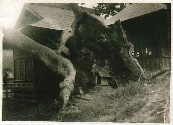
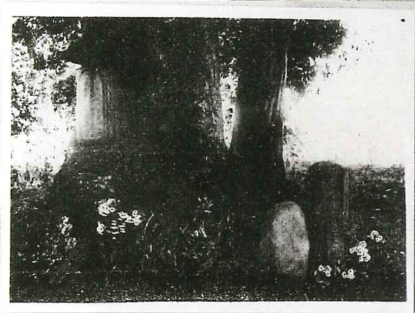
| 現在瑞穂町域には、発掘調査等の結果確実に古墳とされる遺跡はないが、加藤塚や石畑神明神社境内にはかつて塚状の盛土があったといい、一説にはそれらを後世の人が墓や神社に転用したという。石畑地区にある神明神社境内には、今も樹齢千年以上とされるケヤキがあり、加藤塚の塚上にも大ケヤキがあった。古い樹木の存在は、塚が古くから存在したことを推測させる。 | In the Mizuho area, no sites have been definitely confirmed by excavations, etc., to be ancient tombs. However, there was once a mound-shaped embankment in the Kato-tsuka mound and Ishihata Shinmei Shrine precincts, and it has been said that later generations converted these into a tomb or shrine. Within the Shinmei Shrine precincts in the Ishihata district, there is still a zelkova tree that is said to be more than 1,000 years old, and there was also once a large zelkova tree on the mound of Kato-tsuka. The presence of the old tree suggests that the mound had been present for a long time. |
| 仮に古墳が存在したとすると、周辺に墓を造成した人々の集落の存在が予測される。しかし、現在のところ集落遺跡は発見されてない。 | If the ancient tomb did exist, it is expected that the dwellings of the people who constructed it would be evident nearby. However, no such settlement site has so far been found. |
| だが、狭山池東岸の狭山遺跡で、狭山池から東へ続く人工の溝が発見されている。水田開発等で池水を利水する目的で開鑿(かいさく)されたと思われる。しかし、溝は長期間使用された痕跡が見られず、その有効性は明らかではない。 | Nonetheless, a man-made ditch, leading eastwards from the Sayama Pond, has been found on the east bank of Sayama Pond at the Sayama site. It seems to have been cut to draw water from the pond for paddy field development. However, since the ditch shows no traces of long-term use, its effectiveness is not clear. |
| |

神明神社のケヤキ
(昭和年間。ケヤキの根元から右の本殿覆屋にかけて塚の斜面が見える。)
A Zelkova tree of the Shinmei Shrine
(A photo from the Showa era, showing the slope of the mound from the root of the zelkova to the main shrine’s shelter hall on the right.) |
| |

加藤塚
(昭和9年頃。塚上に墓石と大樹がみえる。)
Kato Mound
(photo circa 1934, showing an engraved tombstone to the left of a large tree on the mound). |