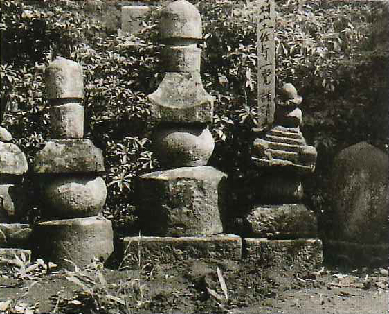
村山土佐守墓
The grave of Tosanokami Murayama |
| |
| 中世の武蔵国は、武蔵七党とよばれる武士団が活躍する時代であった。鎌倉幕府成立に際しては、関東武士が大いに活躍し、幕府の要職を占めた。その後弘元3年(1333年)に鎌倉幕府が滅び、室町幕府が成立する。関東には小幕府ともいうべき鎌倉府が設置され、たびたび対立したことから、その政権は安定しなかった。15世紀半ばに幕府の権力が衰えると、関東は他地域に先んじて戦国時代を迎え、関東武士は戦を繰り返す。16世紀になると後北条氏が南関東から勢力を広げ、多摩地域も16世紀後半には後北条氏の支配下に置かれた。 | The Middle Ages in the Musashi Province was the time when samurai groups called the Musashi Seven Parties played a prominent role. The Kanto samurai were key figures in establishing the Kamakura Shogunate and occupied key posts of the shogunate. Later, when the Kamakura Shogunate fell in 1333, the Muromachi Shogunate was established. Because Kamakura-fu, a type of small shogunate, was installed in the Kanto region, and was in frequent turmoil, the central government of the Muromachi Shogunate (in Kyoto) was unstable. When the power of the shogunate declined in the mid-15th century, Kanto entered the Warring States period ahead of other regions, and the Kanto samurai continued their conflicts. In the 16th century, Go-Hojo expanded its power from South Kanto, and the Tama area was placed under the control of Go-Hojo in the late 16th century. |
| 殿ケ谷地区一帯には、戦国時代後期(16世紀後半)、後北条氏麾下(きか)の村山党の一派である村山土佐守義光が居館を構えていたという伝承が伝わる。この村山氏は、後北条氏と命運を共にし滅亡したという。 | Right across the Tonogaya community, the legend has been passed on that Yoshimitsu Tosanokami Murayama, a faction member of the Murayama Party under the command of Go-Hojo, had his residence there in the late Warring States period (late 16th century). This Murayama clan was said to have been destroyed along with the Go-Hojo clan. |
| 天正10年(1582年)、戦国大名武田勝頼が織田信長に攻められ滅亡するが、その際現山梨県の上野原城主だった武田氏配下の加藤丹後守景忠が箱根ケ崎まで逃れてきて滅亡し、加藤塚に葬られたという。 | In 1582, the warring lord Katsuyori Takeda was attacked and killed by Nobunaga Oda. At that time, under the command of the Takeda, Kagetada Tangonokami Kato, lord of the Uenohara castle in the present Yamanashi Prefecture, escaped to Hakonegasaki where he was killed and it is said that he was buried in the Kato-tsuka mound. |
| 瑞穂町周辺では、狭山丘陵南麓側に「村山郷」と呼ばれる郷村があったとされている。近世前期に成立した「正保年中改定図」には、狭山丘陵南麓の現瑞穂町一帯に「村山村」とあり、これが中世の村山郷に相当する集落と思われる。この地域における殿ケ谷・石畑(畠)、箱根ケ崎は、江戸時代中期に作られた「元禄年中改定図」には見られることから、上記集落は元は村山郷内の小集落だったようである。 | Around Mizuho, a village called "Murayama-go" is said to have been situated on the south foot side of Sayama hill. In the "Shoho-nenchu Kaitei-zu (Revised Map of the Shoho Era [1645-1648 AD]) ", established in the earlier part of the early modern period, "Murayama Village" occupied the entire area of modern Mizuho, at the southern foot of Sayama Hill and this seems to be the community, which corresponds to the Murayama-go village of the Middle Ages. From the fact that Tonogaya, Ishihata and Hakonegasaki were found in this area in the "Genroku-nenchu Kaitei-zu (Revised Map of Genroku Era [1688–1704 AD])" made in the middle of Edo period, these villages seemed to be originally small communities within the Murayama-go village. |
| 対する狭山丘陵北麓には「宮寺郷」があったとされ、前述の近世前期の絵図には、狭山丘陵北麓の現瑞穂町一帯には、「宮寺町」とあり、これが中世の宮寺郷に相当する集落と思われる。高根・駒形・坊の集落名は、前述の江戸時代中期の絵図から出現することから、上記集落は宮寺郷内西端の小集落であったと思われる。 | On the other side, on the northern foot of Sayama Hill, there was said to be a "Miyadera-go". In the above-mentioned map made in the first half of the early modern period, "Miyadera-cho (Miyadera Town)" was shown as the whole area of the northern foot of Sayama Hill, the present Mizuho, and this seems to be the village corresponding to Miyadera-go of the Middle Ages. Since the village names of Takane, Komagata and Bo appeared in the above-mentioned map of the mid-Edo period, these villages seem to have been the small communities in the western end of Miyadera-go. |